All posts by Live Where You Are

Explorer of neighborhoods, parks, trails, and eateries in the St. Louis region. Appreciator of words, photographs, the stillness of nature, and a good period British drama.

Twelve Hikes, Twelve Months

This year, I’m trying something different. Instead of setting lofty, opaque resolutions that I have little hope of following through with, I have settled on a singular, concrete goal.

Every month, I will hike somewhere new.

Whether a new park, or simply a trail I haven’t explored before, I have challenged myself to extend beyond my familiar favorites – Creve Coeur Lake, Queeny Park, and Castlewood State Park, for instance.

20170211_122233

These St. Louis staples I have walked and hiked numerous times in the past three years. This year, I want to renew my spirit of exploration and push the boundaries of my mental map.

It’s time to explore more thoroughly to the south, west, and north. Although I consider myself a Missourian now, I haven’t seen much of the state outside St. Louis. And while I don’t know how far (literally) I’ll go in pursuing my goal, it will prime the pump for more adventures, road trips, and seeing my adoptive state up close and in person.

I hit the mark in both January and February, and will need to follow up with posts about those outings to Shaw Nature Reserve and New Salem State Park. I’m ticking off March tomorrow, going to explore a conservation area I spotted on a map earlier this week. It will be good fun with good friends, and two very sore legs thereafter.

Whatever you’re focusing on in 2017, I hope it’s a success. Lay out your goal, a plan of action, and just stick with it.

Happy trails.

An Accidental (Mis)adventure at Blackburn Park

Sometimes, life needs a dose of spontaneity—and that’s exactly what my friend Stephanie and I got ourselves into recently when I casually posed the question, “What if we just turned left at the next stoplight?” We had just finished eating lunch and were driving back from a nondescript diner in South County that I had wanted to try for awhile. A little disappointed from that experience, I was feeling restless.

Stephanie gamely took the bait, saying “Why not?” After all, we were driving on a thoroughfare that cut through neighborhoods teeming with unique, mid-century brick homes. We both enjoy random adventures and exploring neighborhoods, so the next left-hand turn would likely deliver on both accounts.

Oh yes, it did.

After traipsing down several side streets and gazing admiringly at row upon row of modest and beautiful houses, we took another left-hand turn. This time, instead of launching us into another neighborhood, we ended up parallel to what appeared to be, of all things, a park.

“Turn into the parking lot,” Stephanie insisted. Driving up to the sign, I saw it read—Blackburn Park. A moment later, something registered. “Blackburn Park! This is crazy! I was just looking at this on Google Maps the other day, and have really been wanting to come out here!” When I get excited, the feeling can be hard to physically contain. “I can’t believe we ended up here!”

20160827_170131

20160827_170201

As we got out of the car, I realized an additional two things. One, my phone had very low battery, and my car charger was sitting on the kitchen table at home. And two… did I just hear thunder?

Undeterred, Stephanie spearheaded the exploration, starting by veering off the wide brick path that appeared to cut through the center of the park. On we went to inspect knobby old trees, stand under park shelters that more closely resembled Spanish-tiled villas, and watch two squirrels whirling around tree trunks, locked in an endless chase.

20160827_165909

20160827_165946.jpg

Almost every time we hang out, something inevitably leads to a photoshoot. Since my phone has a higher quality camera, we pulled it out for several shots, warily watching the battery creep lower, but unable to resist the advantageous scenery around us. Since you’re seeing this post, you know we came away unscathed, and my phone battery eventually did recover. But in the moment, it added an extra bit of urgency and hilarity to the proceedings.

20160827_170253

20160827_170357

A group of teenagers was hanging out in the center of the park, and I couldn’t help but think what an unusual sight it must have been to them when we spotted a Swallowtail butterfly and followed its erratic flight path, trying to take a picture before it disappeared in the tree canopy.

20160827_171619

Meanwhile, the column of clouds approaching from the west continued to climb higher. With the underbelly turning a dark shade of blue, I was getting a little nervous about being caught out in the storm. But on the playground we passed, kids continued to play and parents continued to watch. Walkers continued walking, and occasional bicyclists kept passing through.

20160827_170808

20160827_172002

While taking a rest under one villa/shelter, a young mom approached and commented that she was inspecting the shelter for an upcoming birthday party for her child. “It’s a beautiful place for that,” we agreed. She lingered for a few minutes, sharing snippets of her plans for that day and details of the community pool, before resuming her afternoon errands. It was a breath of fresh air to meet a stranger in that random place, at that random moment, and share some bits of small talk. It reminded me of the good rooted deep in our neighborhoods, the togetherness and sense of community that perhaps helps form the backbone of society.

Right then, another roll of thunder jolted me to attention. “Let’s keep going,” I suggested, and Stephanie agreed.

Meandering down several paths, we got an overall good scope of the park. And it was beautiful. Everything I’d hoped to find when I examined the square of green from my laptop, just the week prior.

20160827_171935

20160827_170139

The storm clouds were almost directly overhead now, threatening to release fat droplets of rain, and my phone battery couldn’t take much more excitement. So we descended a hill back into the parking lot, laughing at the adventurous misadventure that had just befallen us. I turned the engine on and directed the car back toward the street.

“Which way should we go?” Stephanie asked.

“How about that way. Past the stoplight and up over the hill. I was wondering what’s over there when we drove by earlier.”


Know Before You Go

Address: 394 Edgar Rd, Webster Groves, MO 63119

Hours: 6 a.m. to a half hour past sunset.

Facilities: There are two locations with restrooms in the park. Several shelters (which may need to be reserved ahead of time) and picnic tables are also available. There are tennis courts, a bird sanctuary (which we didn’t get to, but sounds neat), a playground, and other amenities tucked throughout its 38 acres.

Trails: There are paved walking paths throughout the park. See this map from the City of Webster Groves.

General Info: With walking paths, shelters, and loads of shade from mature trees, Blackburn Park is a very restful place to enjoy a birthday party or just walk and think. In 2012, the Riverfront Times highlighted Blackburn Park as the best birdwatching opportunity in the St. Louis area. Curious about its history, I found that the park was created when an inventor named Jasper Blackburn and his wife donated their land to the city of Webster Groves for the purpose of a park. There doesn’t seem to be much out there in terms of a good history of the park, so if you find more, comment and share below!

Thornhill Estate at Faust Park: This Photography Lover’s Best Kept Secret

If you like photography—whether you’re an amateur or seasoned professional—you likely have a favorite spot or two for whipping out your camera whenever you get the chance. I am no different.

Just a few months after moving to St. Louis, I stumbled across a location that I’ve come back to time and again—with friends and by myself, for my own engagement and wedding photos, and even recently to try out my first ‘real’ big girl camera. Every time I return, I know where to head for reliably beautiful backdrops. And so far, it’s never failed that a different aspect of this place has captured my attention and imagination, whether I’m in front of or behind the lens.

This place is Thornhill Estate. Tucked behind Faust Park in Chesterfield, Thornhill is where Frederick Bates, Missouri’s second governor, called home.

The estate is comprised of a stately white house and a collection of well-preserved barns and other outbuildings, all perched atop a sloping hill at the end of a long gravel drive. Dotted with features like rows of mature trees, a period vegetable garden, and an open expanse of field, the grounds are filled with photo opportunities from end to end.

2336
A front view of Gov. Frederick Bates’ house at Thornhill Estate.
backup-pictures-from-december-2013-1489
A side view of Gov. Frederick Bates’ home at Thornhill Estate.

According to a site history I found from St. Louis County Parks, Gov. Frederick Bates had the house constructed around 1820 in a style inspired by homes from his native state of Virginia. Shown above, one feature of the home (when viewed from the front) is a symmetrical floor plan.

backup-pictures-from-december-2013-1498
Behind the house are several small outbuildings, a garden, and not pictured, a small family burial plot.


248
A line of old, mature trees separates the field from the grounds surrounding the house.

I first discovered Thornhill while exploring Faust Park with a good friend. After walking around the front of the park outside the Butterfly House, a popular attraction Faust Park is known for, we drove through the roundabout skirting the Butterfly House to see what else we could find. As we started down a gravel drive that appeared to be an extension of the park, we almost questioned whether we were entering private property. But as the beautiful farm came into view up the hill, I realized we had just stumbled upon a gem of a historic site. A sign at the wood fence separating the property from the parking lot confirmed that it was okay to explore.

I’m pretty sure my friend and I had the entirety of Thornhill to ourselves during that initial visit—and that’s something that has struck me every time I’ve gone back. There are typically not many people there. This scarcity of visitors adds to the appeal of this unique location as a backdrop, or the main attraction, for some serious photography, because there is no competition for the best vantage point or frustration of needing to crop or edit people out of your photos.

After I got engaged, one of my best friends agreed to come to St. Louis and do an engagement session for Nathan and me. We ended up doing two locations: the Gateway Arch (which is where we got engaged), and Thornhill Estate. I must say, Sarah Jacquel Photography did a pretty good job.

dsc_0626-edited-colour-love-faded
One of my favorite photos from our engagement session took place in front of the very barn that captured my heart the moment I laid eyes on it. Photo credit @Sarah Jacquel Photography.

We got some beautiful images in front of the dark wood barn that I admired so much the first time I saw it, as well as other locations throughout the property. It was fall, so the field beside the house offered another gorgeous backdrop. On a side note, every season is an ideal time of year to visit Thornhill. In autumn, the golden color of the field makes for an awesome background, and in June, the edges of of the same field are filled with soft purple flowers.

dsc_0838-edited-colour-love-courageous
An engagement photo in the field beside the main house at Thornhill Estate. Photo credit @Sarah Jacquel Photography
2330
Purple flowers show up at Thornhill in late spring.

When Nathan and I got married in 2015, we went back to Thornhill after the reception for a special photoshoot with our wonderful photographer, Woven Bone Photography.

img_4237
One of the many beautiful images from a special wedding session at Thornhill Estate. Photo credit @Woven Bone Photography

Once again, we got some photos in front of the dark wood barn, as well as the front of the house, and other locations around the property. And like almost every time I’ve been there, we barely encountered anyone. That made it much easier to relax and be ourselves, which I think showed through in our photos.

img_4117b
Sitting on the front steps of the house at Thornhill Estate. Photo credit @ Woven Bone Photography

For me, Thornhill is an oasis from a busy and fast paced life. It’s easy to get caught up in the minutiae of the everyday. This place forces me out of that. I never expected I’d end up living and working in a larger metropolitan area, so it was an unexpected treat to find this undisturbed piece of land—and slice of history. Each step into the property takes me further back in time and allows me to wonder and marvel at the beauty around me. I’ve always left feeling refreshed… and mentally planning my next Thornhill visit.

So all of this is to say, if you’re in St. Louis and looking for a good location for a photo op, you now know my personal favorite and best kept secret. Feel free to share some images if you get out that way!

231

2279

240

Know Before You Go

Address: 15185 Olive Blvd, Chesterfield, MO 63017

Hours: 7 a.m. to a half hour past official sunset.

Facilities: Bathrooms are available near the front of Faust park by the playground area. There are some picnic tables on a hill behind the main house (pictured above).

Trails: The Governor Bates Trail (named for the governor who resided at Thornhill) is just over a mile long and begins at the estate. It’s rated as difficult (as of this post, I haven’t yet hiked it).

General Info: If you’re a thorough explorer, you could spend over an hour poking through the nooks and crannies of the Thornhill grounds. The rest of Faust Park offers a variety of attractions, like a historic village, playground, the Butterfly House (which is managed by the Missouri Botanical Gardens), and the Carousel.


St. Louis County Parks: Cliff Cave Edition

Did you know that the St. Louis County park system has at least forty parks? You’d have to visit one just about every weekend for an entire year to experience them all.

While I’m not quite up to challenging myself to that (at least not in 2016, with the year being two-thirds over already), I’ve consciously been trying to explore more parks and build a better internal map of the recreation opportunities this area has to offer.

One that I ventured to this summer is Cliff Cave Park. Situated in the southernmost part of the St. Louis metro region, it hugs the curves of the mighty Mississippi River. As its name suggests, the park boasts towering bluffs, and somewhere in it, a cave that I haven’t laid eyes on yet.

My husband Nathan and I drove there on a whim one Saturday afternoon, and not being the best dressed for prolonged outdoor activities, decided to stroll along the loop north of the main parking lot and pavilion (see the map above), rather than venturing on a several mile long loop in another part of the park.

From the parking lot, we could see the park’s namesake cliffs extending to the south. Atop the cliff right overhead, the roof of a residence was slightly visible, as well as several rows of well tended grape vines. With an abundance of sunshine and being situated on a rocky, mineral rich cliff, I could imagine the conditions creating an excellent terroir for the grapes.

1646
Rows of grapes grow atop a bluff facing the Mississippi River above Cliff Cave Park.

Little did I know, those grapes would have greater significance the more I learned about the park. By the pavilion and restrooms, a covered sign shared information about the park’s history, trails, and ecosystem. Before opening to the public in 1977, the site of Cliff Cave Park passed through several owners, and its uses included a failed winery venture, a spring fed pool, and a marina. The railroad also went through the area, which to me helped explain the long, flat stretch of ground in an otherwise rocky and cliff-covered environment.

1647
A sign near the main pavilion shares tidbits about the park’s past for visitors and history-buff-park-lovers alike.


1651
A map of the park’s trails and amenities, which include a spring, several overlooks, and access to the Mississippi River.

After perusing the park’s background, we started off on the freshly blacktopped path toward the river. From the path, several skinny dirt trails crisscrossed down the embankment to the river’s edge. The sight was too much for me. I veered straight off and followed one to the river and soaked in the view. I hadn’t been so up close and personal with the Big Muddy since an adventure to the confluence of the Mississippi and Missouri rivers nearly a year and a half ago.

1663
A view of the Mississippi River facing the Illinois shoreline.

While I didn’t know it then, as I was standing right by the river, there’s a chance I may have been in Illinois. If you take another look at the map of Cliff Cave Park at the top of this post, you’ll see that the Illinois state line technically doesn’t end at the Mississippi—in some stretches, it crosses over and eats up bits of land we’d typically imagine as being Missouri. Interesting fact of the day, huh?

1672
Looking back from the river’s edge, several skinny dirt trails lead from the main path down to the shoreline.

We both enjoyed the view and eventually trudged back uphill to rejoin the path. For about a mile or so if you follow it north of the parking lot, it offers additional views of the Mississippi (further upstream, we caught sight of a barge making its way down the river) before looping back through a wooded area that almost resembles a swamp.

1676
A spiky looking flower growing along the trail at Cliff Cave Park.

Overall, it made for a nice walk on a humid summer afternoon. And at a mere 25 minutes from Busch Stadium and the rest of downtown, it’s an easy escape to get back in touch with nature.

1677
A flat, paved trail follows along the Mississippi River.

I’m really hoping to return again soon, this time with hiking gear, so I can explore the southern loop trail that leads to several overlooks. With the flat terrain and nicely finished path, it’s also ideal for runners and bikers looking for a change of scenery.

See you there soon!


Know Before You Go

Address: 806 Cliff Cave Rd, St. Louis, MO 63129

Hours: 8 a.m. to a half hour past official sunset.

Facilities: Bathrooms available, as well as a picnic shelter that can be reserved.

Trails: The main trail, known as the Mississippi River Trail, is an approximately 5 mile paved loop, in the flatlands right next to the Mississippi. For more information, including videos that highlight each of the park’s trails, head on over to the St. Louis County Parks and Recreation website.

General Info: Visit the Great Rivers Greenway website for some great information to plan ahead for a visit. The St. Louis Post Dispatch also did a thorough review of the Mississippi River Trail.


Phantom Forest and Bittersweet Woods

Every once in awhile, I pull up Google Maps and scroll my way through various areas near St. Louis, watching out for green squares that may indicate the existence of a park. This is how I stumbled across Phantom Forest and Bittersweet Woods.

Both patches of forest are conservation areas, and they’re located one mile south of Manchester Road (also known as Highway 100), the east-west artery that connects West County with St. Louis.

These parks caught my attention awhile ago. When I first spotted them on Google Maps, I had no idea how two small, oddly shaped conservation areas had wound up in the middle of a suburb. They’re just a few miles from my home, and each time I drove past the Barrett Station Road intersection on Manchester, I thought about exploring them.

Recently, I got my chance.

It was the middle of the week, and I came home one evening with the itch to get out and wander; to explore something. It happened to coincide with one of my husband’s evenings off, and although it was hot and muggy outside, he willingly obliged my desire to drive out and explore these two conservation areas.

We parked at the Phantom Forest Conservation Area, which is accessible off Barrett Station Road in Des Peres. The area has its own small lot. There was one other car aside from ours, but we ended up having the trail all to ourselves.

1178
The entrance to Phantom Forest Conservation Area.

The trail going into the woods was covered in wood chips and gradually turned into a skinny dirt path. Although small, the surrounding woods were beautiful, filled with a variety of tree and plant species.

The area had obviously remained untouched for years. As you can see below, trees towered overhead, and sunlight filtered through the dense canopy.

1192
A sunset view from the trail running through Phantom Forest Conservation Area.

Soon the trail split, and we followed the fork to the right up a steep hill. Near the top, we passed a few benches and found a plaque that explained the origins of the park. The stone monument explained, “The Missouri Department of Conservation acknowledges the gift by Claire L. Moore of this thirteen acre natural area, an oasis for all to enjoy. This conservation area has been named for the comic strip hero ‘The Phantom,’ for which Ray Moore was the original cartoonist.”

My husband, an aficionado of many comic book series, immediately got the reference to The Phantom. I myself had to do some reading up to find out more about the park donor.

1199
A monument atop a ridge explains the origins of Phantom Forest.

After enjoying the view and retracing our steps to the main trail, we continued on until the woods abruptly ended. The trail continued on, but we found that it led right behind the fenced backyards of multistory houses.

I spotted a lady who was gardening in one of the enclosed yards and called to her, asking if the path was private or open for walking. She walked right up to the fence and talked with us for several minutes, explaining that the path linked Phantom Forest with Bittersweet Woods. It turns out she was the liaison between the neighborhood and a conservation officer who tends to both patches of woods and maintains the trails. Her two dogs ran around energetically while we talked, and she added that she walks them daily on the trail. Before we headed on, she also let us know about the existence of a small patch of prairie on the other side of the houses.

We briefly left the trail and wandered up into the neighborhood to look at the patch of prairie she had mentioned. I looked up some of the flowers later, and it looks like the prairie was filled with coneflowers and a delicate purple flower called bergamot. (And since I’m not as knowledgeable about flower identification, feel free to comment and correct if I’m wrong here.)

1217
Miniature patch of prairie in Des Peres neighborhood.
1222
Hillside covered in prairie plants and flowers.

After admiring this prairie oasis, we returned to the trail and walked through Bittersweet Woods, which at 10 acres, is slightly smaller than 13-acre Phantom Forest. The trail was a little wider and covered in wood chips, but its elevation varied greatly as we ascended a few big hills. In the distance, we could spot the backyards of many large homes that abutted the woods.

1226
The entrance to Bittersweet Woods Conservation Area, which adjoins Phantom Forest.

Daylight started to fade as we followed the connecting path back into Phantom Forest. We picked up the pace. We followed the trail to the right instead of left (where we came from), and this time it was pretty flat, and we hiked through the lowland section at a good clip.

It wouldn’t be an adventure without a good obstacle, though, would it? When we were almost back to the parking lot, we spotted two male deer sporting antlers who were blocking our path. One casually walked into the woods and continued to graze, while the other just stood there, occasionally looking over his shoulder at us. We weren’t going to walk right into it and possible provoke it, so we stood there. After a few minutes, we almost turned around and retraced our steps, but at last both deer crossed the trail and continued foraging elsewhere.

1232
A deer standing on the trail in Phantom Forest.

Overall, Phantom Forest and Bittersweet Woods are two little gems of wilderness in an otherwise tamed and developed area. They gave me a glimpse of what this part of Missouri looked like when it was blanketed in woods.

Know Before You Go

Address: 2660 Barrett Station Road, St. Louis, MO 63021

Hours: Sunrise to sunset.

Facilities: None. Use the bathroom if you need to before you hike here.

Trails: If you hike through both Phantom Forest and Bittersweet Woods, it’s under 2 miles. For more detail, take a look at this map from the Missouri Department of Conservation.

General Info: Also visit the Missouri Department of Conservation’s website for an overview of the park’s history and general information.

The St. Louis Arch Is Turning Fifty

Have you been to the Arch half a dozen times? Or never been before?

Now might be a good time to plan a visit, because this iconic St. Louis monument is turning fifty next week!

The Gateway Arch’s official birthday is being recognized on Wednesday, October 28, the day the final section of steel was put in place. If you can make it out for the 11 a.m. ceremony commemorating the event, you might land yourself a free cupcake. But even if you don’t, you can take advantage of dollar rides to the top of the Arch all day.

If you’re free this Saturday (the 24th), head to Kiener Plaza downtown for the Arch 50 Fest. I read there will be lots of food, children’s activities, and a fireworks display to cap it off at the end of the night.

Either way you slice it, these are two prime opportunities to get out and connect with your inner St. Louisan.

Know Before You Go

Before embarking on adventure to visit this historic monument, why not brush up on your history of it?

The Gateway Arch website has a neat, concise timeline with several  highlights from the Arch’s storied past. For instance, did you know the idea behind having  a monument on the St. Louis riverfront dates back to 1933?

Additionally, note that entry to both Arch 50 Fest (Saturday, Oct. 24) and the Recognition and Birthday Ceremony (Wednesday, Oct. 28) is free.

Symphony in the Park

With leaves changing and temperatures dropping, I see this post as a sort of summer send-off. A farewell-for-now recap of one beautiful, warm evening in September.

It was a Tuesday, and I was so excited because this night had been planned for nearly a week. While combing the internet for an inexpensive date ideas, I’d stumbled upon a slew of options, one of them being a free concert in Forest Park. And not just any concert..

A St. Louis Symphony Orchestra concert.

My husband and I are great appreciators of the Symphony; not only for the enriching cultural experience and the wonderful performances, but also for the reminder of our engagement. We attended the 2013 New Year’s Eve Celebration the night we became engaged.

So having the opportunity to see the Symphony again, for free, outdoors, in a world-class parkit was all rather appealing. And did I mention there were also going to be fireworks?

A Matter of Parking

As the concert was scheduled to begin at 7, we wanted to arrive early enough to find parking (a considerable challenge for Forest Park at times) and secure good seats on Art Hill. We arrived at least forty minutes early and found parking about three quarters of a mile away.

There were many more people than I had expected. But hey, it is the Symphony. Droves of cars entered the park single file, pushing as far inward as possible before finding somewhere to pull off.

Cars Parked for St. Louis Symphony Concert

Nathan grabbed the picnic basket, and we joined the steady stream of concertgoers filtering from their vehicles and onto the sidewalks. It was a gorgeous night for a walk, with clear skies, little to no wind, and temps hovering around the high 70s to low 80s.

When we finally crested a hill that revealed the full view of Art Hill, we could see a large dome had been erected for the Symphony to play in, and the lawn was beginning to get crowded. Even so, we found space in the grass to spread a blanket and settle in for the night’s events.

Concertgoers on Art Hill


Enjoying Our View from Art Hill

Picnic Possibilities

One of the perks of this being an outdoor concert was, the sky really was the limit as to your food choices and what you could bring. Nathan had stopped at Sam’s Club and brought plates and silverware from home. Below, you can see our delectable dinner. Turkey salad wraps with pineapple, anyone?

Turkey Salad Wraps and Pineapple

Also, a good picnic basket, tote, or other structured bag is a great idea if you plan on attending any outdoor event like this. Ours held food, a bottle of wine (entirely permissible in Forest Park), bottled water, plus plates and silverware.

Picnic Basket

Music

The concert was a preview of sorts of the upcoming 2015-2016 schedule. If any theme could be picked out from the music, I’d say patriotic and upbeatwe heard tunes including “St. Louis Blues March” and “America the Beautiful.”

My absolute favorite, however, was John Williams’ “Flying Theme from E.T.” Imagine sitting under the stars at Forest Park with the uplifting, energetic, yet almost ethereal quality of that live performance. It was something I’ll never forget.

Symphony Playing at Night

By the way, if you’re sad you missed that, just wait until April. Then, you can attend a screening of the movie, and the Symphony will be playing the entire score live.

Oh, and I couldn’t forget…

The Fireworks

The show ended with a pretty spectacular fireworks display, complete with a frenzying finale.

Couple Watching Fireworks


Fireworks at Forest Park

What a way to cap off the summer.


Know Before You Go

While the concert covered in this post has already come and gone, check out the Symphony’s website for a list of upcoming, and entirely free, concerts.

The calendar extends from this month all the way through next spring, so there are plenty of opportunities to experience world class music.

Venues, orchestration, and music will vary from event to event, so plan ahead and catch the one you think you’ll enjoy the most. Or, go outside the box and catch one of the more unique concerts, like one on January 14, 2016, featuring just the Symphony’s trombonists.

Celebrating National Coffee Day (with Free Coffee)

Because I like coffeeand better yet, free coffeeI wanted to share with you some momentous news.

Tomorrow, Tuesday, September 28th, is National Coffee Day.

Coffee

Which, for many coffee shops, chains, and cafes around the country, means a free or discounted cup o’ brew.

I did some research, and these seem to be the chains offering deals in the St. Louis area:

  • Dunkin DonutsDunkin’ Donuts hot or iced Rainforest Alliance Certified™ Dark Roast Coffee, with a limit of one per guest.”
  • Krispy Kreme“a free Original Glazed Doughnut and a free 12 oz cup of coffee (at participating US locations).”

Don’t forget to check out your favorite local coffee shop! Either way, tomorrow is a great reason to celebrate the delectable aroma and taste of coffee.

And maybe a cupcake too.

Homemade Cupcake

Castlewood State Park: A Photo Tour of Lone Wolf and River Scene Trails

Recently my husband and I went exploring at a local state park near where we live. Castlewood State Park, which sits nestled in a bend of the Meramec River, is a mere 15 minutes from our front step. I had been to the north section of the park once before, this spring, but at the time it had been far too muddy to hit any unpaved trails. This time was different.

The weather was set to be beautiful. Mid 70s, a little breeze, sunny, and most importantly, dry. I made sure to do my research before we left, because on my previous trip I had glimpsed how popular Castlewood is, and how crowded the parking lots can be. I wanted to make sure we knew exactly where we were going and which of the many trails we would  explore.

Our choice for this trip was Lone Wolf Trail.We didn’t know much about the trail, except it was a manageable couple of hours and had some pretty great views of the Meramec. When we found the right parking lot and made our way to the trail head, it looked pretty nondescript. However, as we stepped onto the trail and looked ahead, our necks craned, following the path upward.

The 1.5 loop began with a straight uphill climb on a gravel path.

Start of Lone Wolf Trail

Since we had already made up our minds to do the trail, there was nowhere to go but onward and upward. From that section alone, we can both heartily recommend wearing good tennis shoes or hiking shoes. Thankfully, we both were, otherwise some of the loose bits of gravel could have been problematic.

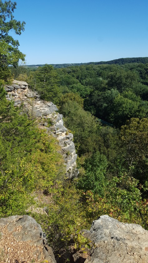
We couldn’t see what lay beyond the fortress-like hill until we nearly crested it. However, the view on the other side was entirely worth the climb.

Meramec River Bluff View

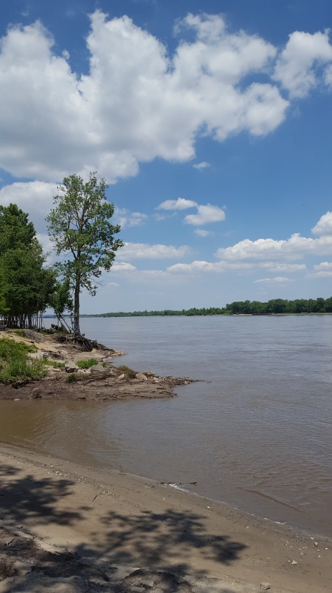
Our eyes were treated to the sight of the Meramec River, lazily flowing around a bend and into the trees. The sky was crisp, clear blue that crowned the forested bluffs and valley below. What a beautiful view. The photo above shows one of the first rocky outcrops we came across with such a view; it was just one of many along this section of trail.

Meramec River Bluff View

After the initial cardiac climb, the trail almost completely leveled out, simply tracing a path through the trees and hugging the bluffs. We imagined it might be a little crowded, but on that part of the trail, we were almost always within sight of people. Many others had apparently also thought it was a nice day for a hike.We came across other couples, both young and old, groups of friends, parents with small children. Nearly everyone was out to enjoy the day.

The River Valley from the Bluffs

When the sweeping vistas weren’t capturing my attention, I kept noticing other interesting, smaller scale sights along the trail. For instance, the neat ground cover pictured below. It seemed to love the shade provided by the towering trees. I wish I knew the name of it. At any rate, I couldn’t help but stoop and take a few closeups for future reference.

Ground Cover along Lone Wolf Trail

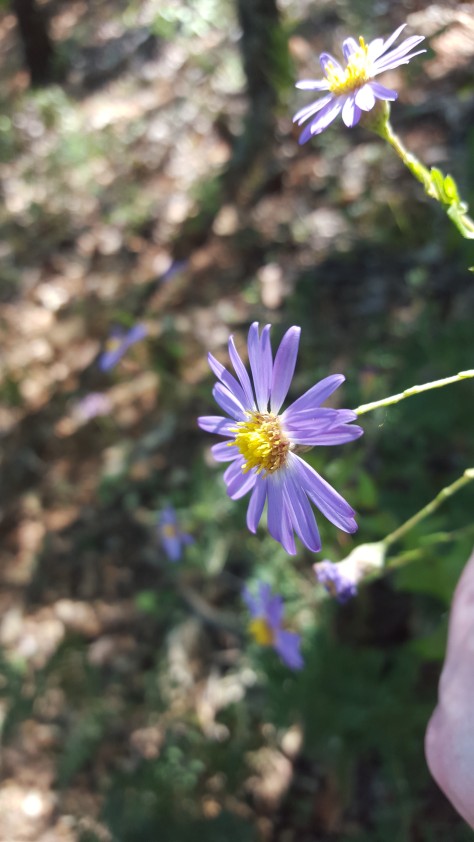
Along the trail, I also noticed a variety of wildflowers. I’m not sure my husband would have appreciated me stopping and photographing every one, but I did get one nonblurry shot of a pretty purple flower that popped up occasionally along the path.

Wildflowers along Lone Wolf Trail

Nathan Standing on Bluff

We hadn’t been hiking long when we noticed something funny about the view below us. If you peered over the edge, you could clearly see train tracks, running right through the state park. It’s not something I had seen before in other parks I’ve visited.

The Bluff, The Railroad, and the River

One time when we looked down, we saw a band of hikers following the tracks. Perhaps they were lost? We weren’t quite sure.

Nathan Standing on a Bluff

But, as you can see, I could not get enough of the views. Lone Wolf Trail solidly delivered on that point.

Nathan Standing on a Bluff

In the photo below, you can kind of see what appears to be a shallow cave in the side of the cliff. It’s the kind of scene that sparks my imagination.

View Down Meramec River Valley

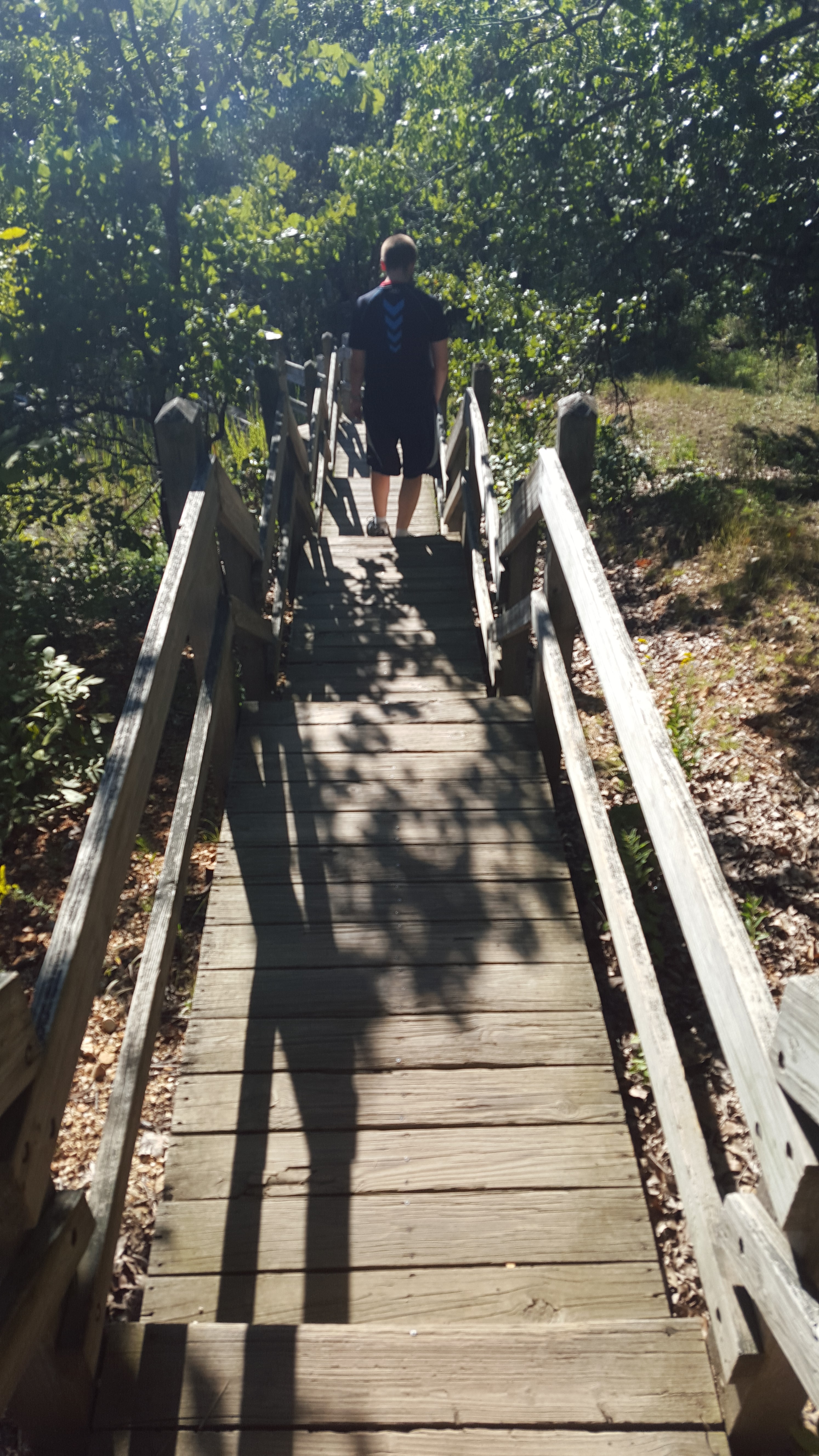
After awhile of hiking along the bluff, we came upon a boardwalk that began a slight descent. Again, there were several places where hikers could pause and stare out at the valley, pondering the beauty and nature around them. It reminded me of some state parks in northern Illinois (namely, Starved Rock State Park and Castle Rock State Park state parks) that have similar boardwalk and bluff views.

The Boardwalk Begins

The wooden stairs also acted as a funnel. Hikers that had previously been (rather purposefully) walking a ways a part to give each group some privacy now had no choice but to enter the fray together. Soon, hikers going downward as we were all but disappeared. Instead, we kept coming across groups of hikers coming up. As you can see below, there wasn’t much room for two to walk abreast down the stairs. But they were solidly built.

Descending To the Floodplain

The Stairs Toward River Scene Trail

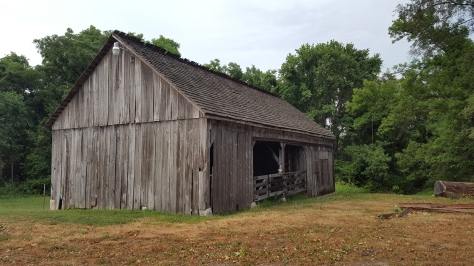
About halfway down, I was looking to my right and saw a few overgrown sets of concrete steps. Who knows when those were constructed, or when they ceased being used. A lot of history surrounds Castlewood as far as its prior use as a summer retreat and party haven (there’s even a website dedicated to sharing stories from that era of the park’s history).

Old Stone Stairs

As the stairs continued a sharp descent, it was clear that we were soon going to be on the floodplain, right next to the Meramec.

Heading Down into the Forest

However, we didn’t know we would go through a tunnel under the railroad tracks. Since the trail passes right through there, it’s probably how other hikers we’d seen from the bluffs had made their way to walking along the tracks themselves.The railroad is actively used, however, so I wouldn’t recommend following in their steps. We heard or saw at least two trains go through as we were hiking ourselves.

Tunnel Under the Railroad

Crossing under to the other side of the tracks was like entering a lost world. Here, the trees and their spread canopies dwarfed the trees growing on the rocky cliffs now a hundred feet above us. Some had trunks so thick, one could only imagine they might be a hundred or more years old.

The River Scene Trail
Trees and the Trail

Old Tree Trunk

The trail here was composed of fine-grain dirt. There wasn’t a single trail, but rather a constantly undulating network of wider and narrower paths. As soon as a few bicyclists passed by us, it was clear the multiple paths probably formed from both hikers and bicyclists trying to navigate around each other.

Also at this point, we started wondering if we were still on Lone Wolf Trail. Luckily, my phone had fairly good signal, so I quickly searched for an answer. We had, in fact, deviated from our original plan somehow and gone off onto River Scene Trail, an aptly named path that thankfully headed in the general direction of our parked car. Getting ourselves back to Lone Wolf Trail would have required ascending the dizzying flight of stairs, so we just kept going.

View of the Meramec from the Trail

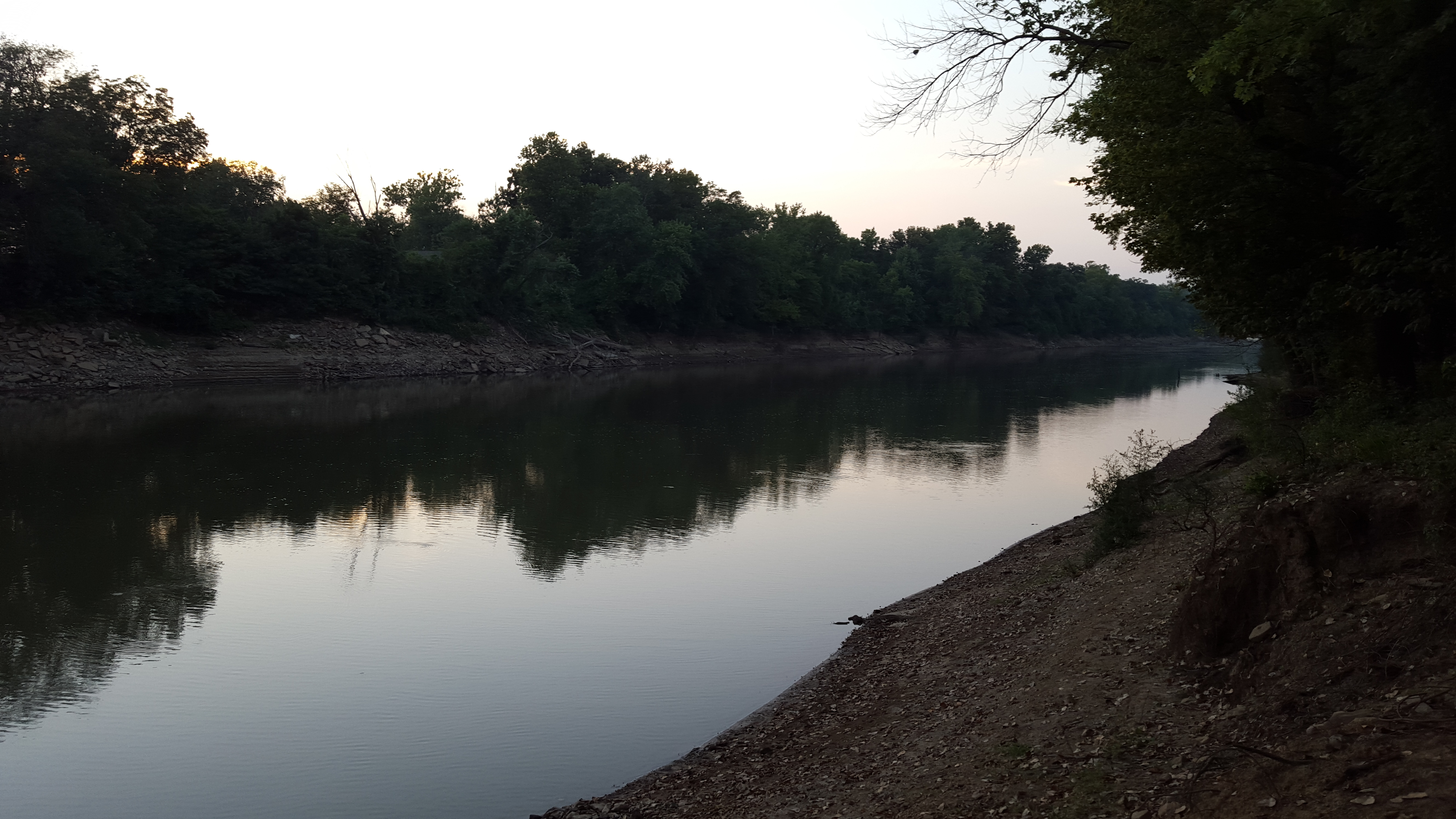
As Lone Wolf had hugged the bluffs, so did River Scene hug tightly to the Meramec. We could often see clearly through the undergrowth and catch glimpses of various sandbars, embankments, and other curiosities at the river’s edge. I’m not sure how the river is for fishing, but a few years ago I went on a float trip down a section of it on a large raft (courtesy of Riverview Rafting). Although Castlewood is no longer used as a resort area, recreational use of the river lives on.

Crossing Under the Railroad Again

After around an hour and a half of hiking, we emerged from the woods along the floodplain. The trail didn’t quite end at our car, so we continued hiking along the road, back under the railroad (albeit at a less tunnel-like pass). The path before us was very clearly etched in the dirt. It reminded me of a rather unceremonious Yellow Brick Road.

Path Back to the Car

But lead us right back to our car it did, and so concluded our first major Castlewood hike. According to the park’s website and several area maps, it’s clear we’ve only scratched the surface of what the park has to offer. There are all kinds of trails, through woods, up steep slopes, overlooking the valley, and venturing into the valley itself.

We will definitely be back soon.

Tired and Happy Hikers

Know Before You Go

Address: 1401 Kiefer Creek Rd, Ballwin, MO 63021

Hours: 7 a.m. to one-half hour after sunset, year-round (park gates open and close at these times).

Facilities: Several shelters, uncovered picnic areas, and restrooms are available.

Trails: For a list of hiking trails and trail descriptions, the Missouri State Park’s website is a good source.

History: Also visit the Missouri State Park’s website for an overview of the park’s history and general information.

Discovering St. Louis County: Sunset at Emmenegger Nature Park

Since June, when I relocated further into the heart of St. Louis County, my eyes have been roving Google maps for new places to explore.

One place that repeatedly caught my interest was a park with a rather unusual-sounding (and let’s face it, fun to say) name. Emmenegger Nature Park. Fenced in by the Meremac River and several crisscrossing interstates, this 93-acre piece of land on the edge of Kirkwood seemed like an unusual spot on a map to be labeled as a park, let alone a nature park. I just had to see for myself.

This weekend, I finally got the chance to explore it, in the good company of my obliging husband.

It was a bit of a tight timeline, as the park closes at sunset. The sun was already low in the sky as we were navigating a series of left-hand turns off the interstate and onto a dead-end road that wound, snakelike, back in on itself before depositing us at the park entrance.

At Emmenegger, there is a single trail head at the base of a small parking lot. Only two other cars were present. Not quite knowing what to expect, we parked the car and started in on the trail.

Rounding a Corner of Emmenegger Nature Trail

As you can see from the above picture, mostly the path went through thick woods, almost in a figure-eight fashion. At a few points, it crossed over a dry creek bed. Although the St. Louis area has been in a dry spell, we were surprised not to see any water.

Dry Creekbed at Emmenegger Park

The woods were rich with vegetation, vines, old trees, and flowering plants. We didn’t spot any wildlife, save for a toad, but boy did we hear the cicadas. Their cacophony accompanied us all throughout the park.

At one point, we ran into a man who appeared out of the brush, walking briskly and shouldering a large backpack. There seemed to be an actual trail from where he came from, but with little sunlight filtering through the canopy, there wasn’t enough time to investigate further. So we continued on, staying a ways behind the man until he veered to head out to the parking lot.

The trail itself isn’t very long. Our overall hike lasted about twenty minutes. The highlight came near the end, when we discovered a spur that led out to the edge of the Meremac River. I eagerly jumped up onto the dirt path, stopping several times to take pictures.

Spur of Emmenegger Nature Trail

The view from the riverbank made this trip well worth it. To our right, the river slowly disappeared around the bend. The water almost appeared purple, soaking up the twilight appearance of the sky. To the left, we could plainly see just how close we were to civilization. The interstate we had driven on to get to the park was well within view, with the whooshing of cars reverberating down to our point on the river. As we had been hiking through the woods, just several hundred yards of foliage had deadened that noise. It was easy to forget that we were within the city limits of a suburb.

View of the Meremac River

We soaked up our surroundings for several minutes. It was hard not to linger, but we needed to get going to beat the sunset.

Before we left, I made sure to take one last shot of my husband looking out over the water.

Looking at the Meremac River

When we loaded ourselves back up into the car and pulled out of the parking lot, we were greeted by a herd of deer that had taken up residence in the park’s green space while we were out walking. They were everywhere.

Deer at Emmenegger Nature Park

For the brief dose we experienced of Emmenegger, I’d say it would be a wonderful, easy jaunt to return to when fall colors are in full swing.

Our late summer, late evening walk here was just the first of many excursions to come.

Know Before You Go

Address: 11991 Stoneywood Dr, St. Louis, MO 63122

Hours: Sunrise to sunset

Facilities: Pavilion, restrooms, 1.5 miles of paved and unpaved trails

History: Visit the Missouri Department of Conservation for an interesting overview of the park’s history (Would it interest you to know that it was once used as an exotic breeding locale by the St. Louis Zoo?)